This moderate linear walk links two stations on the same rail line, with fantastic views and luscious woodland along the way.
Highlights include:
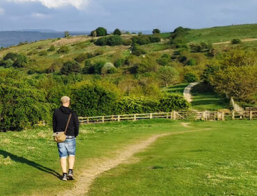
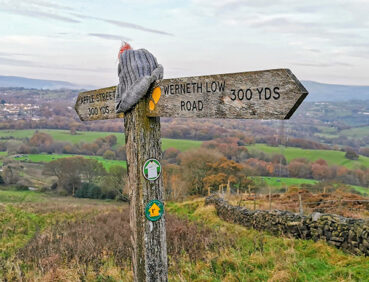
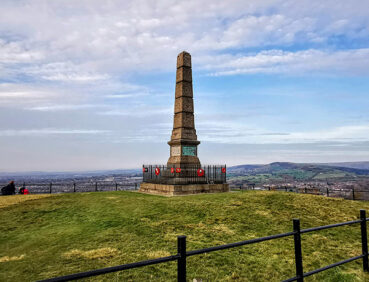
- The hill-top Werneth Low country park, offering great views across Greater Manchester, the Peak District and the Pennines
- Streamside paths in the fairytale-like setting of Back Wood
- Industrial remains and riverside scenery near Broadbottom.
Note that parts of the trail may be damp, muddy and slippery at any time of year and especially after periods of wet weather. Please bear this in mind when planning your trip.
Be sure to keep your dog on its lead in sensitive areas, which include upland areas such as moorland, wetlands and mosslands, farmland, and parkland. Keeping dogs on leads helps protect both livestock and wildlife, especially ground-nesting birds.
This walk is available on the user-friendly Go Jauntly walking app. Here, photographs and written directions will enable you to follow the route on your phone. You can also download a printable PDF of the directions from the same link.
Alternatively, you can follow the route (without written directions) on the mobile-friendly Plotaroute site. To use Plotaroute on your phone’s browser, simply click the map. Then, when you’re ready to start walking, click the tracker icon (bottom right) to show your position as you follow the route.
We recommend carrying an additional power source and/or map when following online routes on your phone. For any challenging routes, we would recommend that you also have access to and know how to read an Ordnance Survey map.
This walk includes a greater amount of ascent and descent than most of the other GM Ringway short walks. Even so, most of the gradients encountered are fairly gentle. However, just after the 3-mile/50km point you descend fairly steeply down field paths from Apple Street to Back Wood – take care here.
The paths used for the first 3 miles/5km are of good quality, ranging from pavements and a hard-surfaced track shared with cyclists to the well-made, mainly compacted gravel paths on Werneth Low. After this point however, the grassy and earthen paths followed can be muddy and slippery, especially on slopes and in the woodland section. Mud and puddles might also be encountered elsewhere.
You will need to watch out for bikes on certain sections, particularly on the multi-user path to the southwest of Godley.
The paths and terrain encountered on this walk are shown and described on the Go Jauntly version of the walk, enabling you to make your own assessment of whether the route is accessible for you.
However, the varied terrain involved in this route means that the overall route is not suitable for wheelchairs or pushchairs. Please visit our Shorter walks page for a selection of step-free walks on the GM Ringway trail.
There are toilets (including accessible facilities) at the 2-mile/3.2 km point at Lower Higham Visitor Centre, though we have found that toilet availability in parks and country parks cannot be guaranteed. There are two pubs close to the first half of the walk route and a café (open Sunday only as of April 2024) at the visitor centre. Near the end point of the walk in Broadbottom there is another pub, as well as a café at Lymefield Garden Centre, approximately 0.5 miles / 800 m from Broadbottom station. For an overview of locations, see the Plotaroute map.
As the GM Ringway is designed around the tram, train and bus network, we recommend the use of public transport to access the start and end points. However, we also provide tips for drivers below.
Start and end points
To work out how to get to and from the walk start and end point, simply click the link below to see the location in Google Maps. Then click ‘Directions’ and enter your starting location. For public transport options, click the train icon.
Start point: Godley station SK14 3SA
End point: Broadbottom station SK14 6AX
Alternatively, input the location shown on this page into the TfGM journey planner.
Public transport
This trail stage connects Godley and Broadbottom stations, both on the Manchester-Glossop line and served by regular trains 7 days a week.
Train times can be checked by visiting the National Rail website.
Recommended tickets
If you are travelling only by train, then a return ticket from your local station to Broadbottom may be the best option. As Broadbottom is further along the line from Manchester than Godley, you can use this ticket on your return journey. (However, if you are travelling from Glossop to the east, then you should buy a return ticket to Godley.)
Depending on your starting location, you should check if a Greater Manchester Rail Ranger may be cheaper (cost £8.20 as of March 2024). This can be used on any train (and trams within the city centre) all day on weekends and bank holidays at off-peak times on weekdays. For details, see this page.
If you are travelling by a mix of buses, trains or trams, then a combined day ticket might be cheaper. Check the TfGM Tickets and passes page to find the best option (selecting ‘1 day and return’ as your answer to ‘How often would you be travelling?’).
Parking
By far the best option for drivers is to park at Broadbottom station (postcode SK14 6AX), where there is parking for 53 vehicles. You can then take one of the regular trains for the 5-minute journey to Godley, where the walk starts. To check times and prices, visit the National Rail website.
We have no reports of any issues affecting this walk. Please let us know if you encounter any problems by completing this short form.