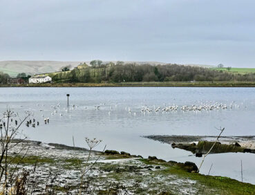
This straightforward but attractive circuit takes you around Hollingworth Lake, the third-largest body of water in Greater Manchester.
Highlights include:
- Beautiful views of the South Pennines from the shores of the lake
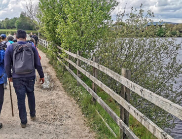
- A stroll along the ‘promenade’ of Hollingworth Lake, recalling its role as an inland holiday destination for workers from the nearby mills
- Plenty of chances to watch the varied birdlife on and around the lake.
Note that parts of the trail may be damp, muddy and slippery after periods of wet weather. Please bear this in mind when planning your trip.
Be sure to keep your dog on its lead in sensitive areas, which include upland areas such as moorland, wetlands and mosslands, farmland, and parkland. Keeping dogs on leads helps protect both livestock and wildlife, especially ground-nesting birds.
This walk is available on the user-friendly Go Jauntly walking app. Here, photographs and written directions will enable you to follow the route on your phone. You can also download a printable PDF of the directions from the same link.
Alternatively, you can follow the route (without written directions) on the mobile-friendly Plotaroute site. To use Plotaroute on your phone’s browser, simply click the map. Then, when you’re ready to start walking, click the tracker icon (bottom right) to show your position as you follow the route.
We recommend carrying an additional power source and/or map when following online routes on your phone. For any challenging routes, we would recommend that you also have access to and know how to read an Ordnance Survey map.
The shorter version of the walk (starting from Lake Bank car park) is almost totally level. For those starting at Smithy Bridge station, there is a gentle descent on pavements to the lakeshore and a corresponding ascent on the return. The path around the lake is hard-paved to the halfway point at the Pavilion Café. The onward route is on a well-made track which can, however, be slightly uneven in places and damp after wet weather.
The paths and terrain encountered on this walk are shown and described on the Go Jauntly version of the walk, enabling you to make your own assessment of whether the route is accessible for you.
While we believe that the route is suitable for wheelchairs and pushchairs, we cannot guarantee this, so be prepared to retrace your steps if you encounter any problems. Please see our Shorter walks page for a selection of further step-free walks on the GM Ringway trail.
Public toilets, including accessible facilities, are available at three locations on or near the route. In addition, refreshments are available at a number of cafes and pubs around the lake, including . For location details, see the Plotaroute map.
There are also several benches and picnic tables along the way.
As the GM Ringway is designed around the tram, train and bus network, we recommend the use of public transport to access the start and end points. However, we also provide tips for drivers below.
Start and end points
There are two locations where you can start and end the walk: Smithy Bridge station for those arriving by train (and completing the longer walk) or Lake Bank car park by the lake shore. To work out how to get to and from either location, simply click the link below to see the location in Google Maps. Then click ‘Directions’ and enter your starting location. For public transport options, click the train icon.
Start point 1: Smithy Bridge station OL15 0DX
Start point 2: Lake Bank car park OL15 0DQ
Alternatively, input the locations shown on this page into the TfGM journey planner.
Public transport
The longer version of this walk, suitable for those arriving by train starts and finishes at Smithy Bridge station, served by trains 7 days a week from Manchester and Rochdale. The shorter version starts from Lake Bank, served by regular buses from Rochdale and Littleborough
Train times can be checked by visiting the National Rail website, while details of bus and tram services can be found on the TfGM journey planner.
Recommended tickets
If you are travelling only by train, you can purchase a return ticket from your starting location to Smithy Bridge. You can check the price of these on the National Rail website. Tickets can be purchased online or from the ticket office or machine at the station.
For those accessing the walk by bus, buses within Greater Manchester cost £2 for a single ticket and £5 for an AnyBus ticket, valid for multiple bus journeys all day and obtainable from the driver (prices correct as of March 2024).
If you are travelling by a mix of buses, trains or trams, then a combined day ticket might be cheaper. Check the TfGM Tickets and passes page to find the best option (selecting ‘1 day and return’ as your answer to ‘How often would you be travelling?’).
Parking
The best option is to park at Lake Bank Car Park (postcode OL15 0DQ), with parking for 90 vehicles and 4 disabled spaces. If this car park is likely to be full, other options are available close to the lake. Visit the Rochdale Council website for details.
We have no reports of any issues affecting this walk. Please let us know if you encounter any problems by completing this short form.
The GM Ringway Team is excited to launch our special GM Ringway Quest in partnership with the Sunnywood Project. Perfect for families, friends, and solo adventurers alike, the quest is a detective adventure using QR codes strategically placed around the lake to discover whether there truly is a monster lurking in Hollingworth Lake, or is it just a myth?
For more information, visit the Sunnywood Project website.
We have also created the Sleuth & Stride Trail on the Go Jauntly App for you to follow.