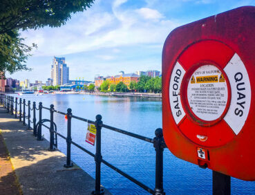
This step-free walk uses explores the Salford Quays waterfront and visits some outstanding cultural heritage sites.
Highlights include:
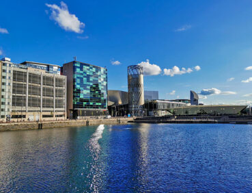
- Waterside paths along the Manchester Ship Canal and the basins of Salford Quays
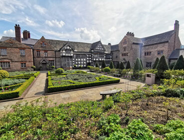
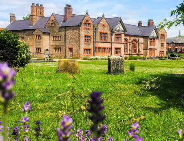
- The Grade I-listed Ordsall Hall, a 15th-century manor house surrounded by Elizabethan gardens
- The striking structure of Imperial War Museum North, designed by US architect Daniel Libeskind.
This walk is available on the user-friendly Go Jauntly walking app. Here, photographs and written directions will enable you to follow the route on your phone. You can also download a printable PDF of the directions from the same link.
Alternatively, you can follow the route (without written directions) on the mobile-friendly Plotaroute site. To use Plotaroute on your phone’s browser, simply click the map. Then, when you’re ready to start walking, click the tracker icon (bottom right) to show your position as you follow the route.
We recommend carrying an additional power source and/or map when following online routes on your phone. For any challenging routes, we would recommend that you also have access to and know how to read an Ordnance Survey map.
The route is almost entirely level, aside from a couple of short, very gentle slopes onto and off the bridges passed along the way. Furthermore, all of the paths used are hard-surfaced. You may need to watch out for bikes on certain sections.
Those not using wheelchairs and pushchairs can vary the route in places by using steps where available.
The paths and terrain encountered on this walk are shown and described on the Go Jauntly version of the walk, enabling you to make your own assessment of whether the route is accessible for you.
We believe that the route is, however, fully accessible for wheelchairs and pushchairs. Please see our Shorter walks page for a selection of further step-free walks on the GM Ringway trail.
Metrolink trams used to reach the start and end point all offer step-free access to and from platforms and level access to and from the trams themselves.
Toilets, including accessible facilities, are available to the public in the Lowry arts centre and the Lowry Shopping Mall, the Watersports Centre, the Imperial War Museum North, and at Ordsall Hall (during opening hours only).
The multiple refreshment opportunities include bars, cafes and restaurants at MediaCity, a café at Ordsall Hall (during opening hours), and a café and pub near Trafford Bridge. For location details, see the Plotaroute map.
There are also several benches and picnic benches along the way and a children’s play area in Ordsall Park.
As the GM Ringway is designed around the tram, train and bus network, we recommend the use of public transport to access the walk. However, we also provide tips for drivers below.
Start and end points
To work out how to get to and from the walk start and end point, simply click the link below to see the location in Google Maps. Then click ‘Directions’ and enter your starting location. For public transport options, click the train icon.
Start and end point: MediaCityUK tram stop M50 2EQ
Alternatively, input the location shown on this page into the TfGM journey planner.
Public transport
The walk starts and finishes at MediaCityUK tram stop, served by Metrolink trams from Manchester city centre and elsewhere, and with easy connections to the rest of the network. There are also bus stops with services to and from various locations nearby. Details of bus and tram services can be found on the TfGM journey planner.
Recommended tickets
If you are travelling only by tram, you will need a Metrolink ticket to cover the zones you travel through. You can check the price of these on the Bee Network website and then purchase your ticket from the machine at the stop or tap in and out with your bank card.
If you are travelling by a mix of buses, trains or trams, then a combined day ticket might be cheaper. Check the TfGM Tickets and passes page to find the best option (selecting ‘1 day and return’ as your answer to ‘How often would you be travelling?’).
Parking
As parking can be busy and somewhat expensive at MediaCity, you are advised to travel to the start point by tram or bus.
However, there are two multi-story car parks on site, one located within Quayside (post code M50 3AH) and one located on Broadway (postcode M50 2TG).
We have no reports of any issues affecting this walk. Please let us know if you encounter any problems by completing this short form.