This is a lovely step-free walk visiting Bramhall Park, Bramall Hall and two nature reserves.
Highlights include:
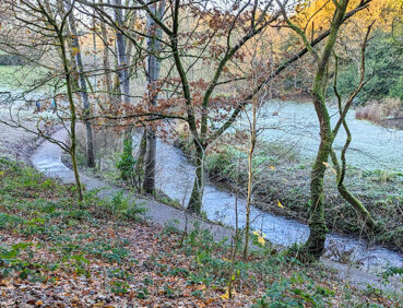
- Carr Wood, a beautiful area of semi-ancient woodland in a gorge-like valley
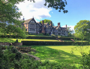
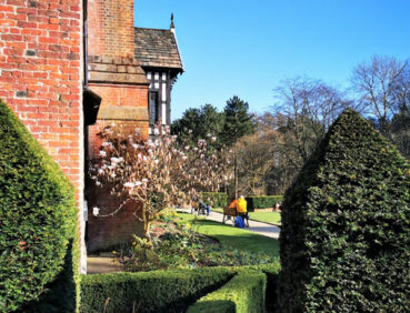
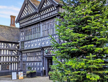
- Bramall Hall, a superb Tudor manor house (Grade I-listed)
- Happy Valley, the first of Stockport’s local nature reserves.
Note that parts of the trail may be damp, muddy and slippery at any time of year and especially after periods of wet weather. Please bear this in mind when planning your trip.
Be sure to keep your dog on its lead in sensitive areas, which include upland areas such as moorland, wetlands and mosslands, farmland, and parkland. Keeping dogs on leads helps protect both livestock and wildlife, especially ground-nesting birds.
This walk is available on the user-friendly Go Jauntly walking app. Here, photographs and written directions will enable you to follow the route on your phone. You can also download a printable PDF of the directions from the same link.
Alternatively, you can follow the route (without written directions) on the mobile-friendly Plotaroute site. To use Plotaroute on your phone’s browser, simply click the map. Then, when you’re ready to start walking, click the tracker icon (bottom right) to show your position as you follow the route.
We recommend carrying an additional power source and/or map when following online routes on your phone. For any challenging routes, we would recommend that you also have access to and know how to read an Ordnance Survey map.
The majority of this walk is on level or gently sloping paths. A mix of hard-surfaced and well-made compacted gravel paths are used. Some paths may, however, be slightly uneven in places and damp after wet weather. To the southeast of Bramall Hall, the route passes through a gap that is approximately 90 cm in width and which may therefore be narrow for some users. There is also one wide ‘kissing gate’, where some users may require assistance.
You may need to watch out for bikes on certain sections, particularly the paths in and around Happy Valley.
The paths and terrain encountered on this walk are shown and described on the Go Jauntly version of the walk, enabling you to make your own assessment of whether the route is accessible for you.
While we believe that the route is suitable for wheelchairs and pushchairs, we cannot guarantee this, so be prepared to retrace your steps if you encounter any problems. Parts of the route may, of course, be more difficult to navigate after wet weather. Please see our Shorter walks page for a selection of further step-free walks on the GM Ringway trail.
Unfortunately, Bramhall station is only partially step-free. However, low-access buses to and from Stockport stop just outside. In addition, low-access buses from Manchester, Didsbury and other locations also stop nearby. See the Plotaroute map for location details.
Public toilets, including accessible facilities, are available at the visitor centre in Bramhall Park.
Refreshment opportunities are available en route at the Stables Kitchen in Bramhall Park. There is also a useful shop on Bridge Lane (just after the Happy Valley section), and plenty of cafes, bars and restaurants in Bramhall Village centre, a short walk to the south of the start and end point. For location details, see the Plotaroute map.
There are plenty of benches and picnic tables along the way and a children’s play area in Bramhall Park.
As the GM Ringway is designed around the tram, train and bus network, we recommend the use of public transport to access the start and end points. However, we also provide tips for drivers below.
Start and end points
To work out how to get to and from the walk start and end point, simply click the link below to see the location in Google Maps. Then click ‘Directions’ and enter your starting location. For public transport options, click the train icon.
Start point: Bramhall station SK7 2DU
Alternatively, input the location shown on this page into the TfGM journey planner.
Public transport
The walk starts and finishes at Bramhall station, served by direct trains from Stockport and Manchester. However, services can be infrequent, especially on Sundays. Bramhall is also served by frequent buses from many locations. Train times can be checked by visiting the National Rail website, while details of bus and tram services can be found on the TfGM journey planner.
Recommended tickets
If you are travelling only by train, you can purchase a return ticket from your starting location to Bramhall. You can check the price of these on the National Rail website. Tickets can be purchased online or from the ticket office or machine at the station.
For those accessing the walk by bus, buses within Greater Manchester cost £2 for a single ticket and £5 for an AnyBus ticket, valid for multiple bus journeys all day and obtainable from the driver (prices correct as of March 2024).
If you are travelling by a mix of buses, trains or trams, then a combined day ticket might be cheaper. Check the TfGM Tickets and passes page to find the best option (selecting ‘1 day and return’ as your answer to ‘How often would you be travelling?’).
Parking
The closest car park to the walk start point is Bramley Close Car Park (postcode SK7 2DT), where there is parking for 90 vehicles and 5 disabled spaces.
Alternatively, there is a car park in Bramhall Park part-way through the route of this walk, but this can be very busy as the Stockport Council website explains.
We have no reports of any issues affecting this walk. Please let us know if you encounter any problems by completing this short form.