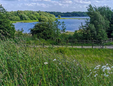
This very attractive route takes you around Pennington Flash, the second-largest body of water in Greater Manchester and part of England’s newest National National Reserve – the Flashes of Wigan and Leigh.
Highlights include:
- Views of colourful yachts and dinghies sailing from Leigh and Lowton Sailing Club
- Lovely quiet field paths on the southern side of the lake
- Plenty of chances to observe a wide variety of water birds, especially from the two hides that overlook ponds just north of the visitor centre
- An exciting children’s play area and ‘The Hide’ café overlooking the lake.
Note that parts of the trail may be damp, muddy and slippery after periods of wet weather. Please bear this in mind when planning your trip.
Be sure to keep your dog on its lead in sensitive areas, which include upland areas such as moorland, wetlands and mosslands, farmland, and parkland. Keeping dogs on leads helps protect both livestock and wildlife, especially ground-nesting birds.
This walk is available on the user-friendly Go Jauntly walking app. Here, photographs and written directions will enable you to follow the route on your phone. You can also download a printable PDF of the directions from the same link.
Alternatively, you can follow the route (without written directions) on the mobile-friendly Plotaroute site. To use Plotaroute on your phone’s browser, simply click the map. Then, when you’re ready to start walking, click the tracker icon (bottom right) to show your position as you follow the route.
We recommend carrying an additional power source and/or map when following online routes on your phone. For any challenging routes, we would recommend that you also have access to and know how to read an Ordnance Survey map.
The great majority of this route is level, with a few gentle slopes and one brief, steeper ascent at the northwestern end of Pennington Flash (near the 3-mile/5-km point).
Many of the paths are well made, especially the hard-surfaced multi-user path between Leigh and the Flash, as well as the paths close to the car park and visitor centre. However, some of the field paths and lakeshore paths elsewhere are variable in quality, with mud and puddles likely on certain sections.
You will also need to watch out for bikes on the multi-user path between Leigh town centre and the car park.
The paths and terrain encountered on this walk are shown and described on the Go Jauntly version of the walk, enabling you to make your own assessment of whether the route is accessible for you.
However, the varied terrain involved in this route means that the overall route is not suitable for wheelchairs or pushchairs. Please visit our Shorter walks page for a selection of step-free walks on the GM Ringway trail. Many of the paths on the eastern side of Pennington Flash are also step-free and well-surfaced, as is the multi-user path between Leigh and the Flash.
Payable public toilets, including accessible facilities, are available at Leigh bus station. In addition, toilets, again including accessible facilities, are located behind the Hide café near the Pennington Flash car park. A range of pubs, cafes and shops can be found in Leigh town centre. For location details, see the Plotaroute map.
There are also several benches and picnic tables along the way and a large, accessible children’s play area at Pennington Flash.
As the GM Ringway is designed around the tram, train and bus network, we recommend the use of public transport to access the start and end points. However, we also provide tips for drivers below.
Start and end points
There are two locations where you can start and end the walk: Leigh bus station for those arriving by bus (and completing the longer walk) or Pennington Flash car park by the lake shore. To work out how to get to and from either location, simply click the link below to see the location in Google Maps. Then click ‘Directions’ and enter your starting location. For public transport options, click the train icon.
Start point 1: Leigh bus station WN7 4LP
Start point 2: Pennington Flash car park WN7 3PA
Alternatively, input the locations shown on this page into the TfGM journey planner.
Public transport
The longer version of this walk, suitable for those arriving by bus, starts and finishes at Leigh bus station, served by express buses from Manchester and Salford and by other buses from Wigan, Bolton and elsewhere.
Details of bus and tram services can be found on the TfGM journey planner.
Recommended tickets
Buses within Greater Manchester cost £2 for a single ticket and £5 for an AnyBus ticket, valid for multiple bus journeys all day and obtainable from the driver (prices correct as of March 2024).
If you are travelling by a mix of buses, trains or trams, then a combined day ticket might be cheaper. Check the TfGM Tickets and passes page to find the best option (selecting ‘1 day and return’ as your answer to ‘How often would you be travelling?’).
Parking
There is parking for more than 300 vehicles at Pennington Flash car park (postcode WN7 3PA), including disabled spaces.
We have no reports of any issues affecting this walk. Please let us know if you encounter any problems by completing this short form.