🚨This route is currently closed until further notice owing to the July 2026 wildfires. We will update the website in due course.🚨
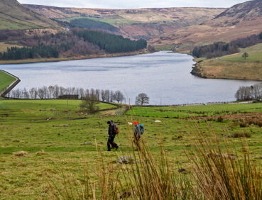
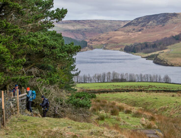
A moderate short walk, with great views, featuring part of the GM Ringway in Saddleworth. The route provides access to the popular Dove Stone Reservoir – an RSPB reserve – on foot from Greenfield train station.
Highlights include:
- Breathtaking views over Saddleworth’s Chew Valley
- A stroll by the shores of Dove Stone Reservoir, set in a dramatic landscape that’s home to an array of wildlife
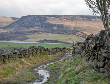
- Chew Piece Plantation, the only remaining area of long-standing deciduous woodland near Dove Stones Reservoir.
Note that parts of the trail may be damp, muddy and slippery at any time of year and especially after periods of wet weather. Please bear this in mind when planning your trip.
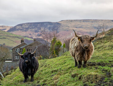
Be sure to keep your dog on its lead in sensitive areas, which include upland areas such as moorland, wetlands and mosslands, farmland, and parkland. Keeping dogs on leads helps protect both livestock and wildlife, especially ground-nesting birds.
This walk is available on the user-friendly Go Jauntly walking app. Here, photographs and written directions will enable you to follow the route on your phone. You can also download a printable PDF of the directions from the same link.
Alternatively, you can follow the route (without written directions) on the mobile-friendly Plotaroute site. To use Plotaroute on your phone’s browser, simply click the map. Then, when you’re ready to start walking, click the tracker icon (bottom right) to show your position as you follow the route.
We recommend carrying an additional power source and/or map when following online routes on your phone. For any challenging routes, we would recommend that you also have access to and know how to read an Ordnance Survey map.
This walk includes a greater amount of ascent and descent than most of the other GM Ringway short walks. While most of the gradients encountered are fairly gentle, there is a fairly steep ascent from the 0.7-mile/1-km point up a tarmac-surface road onto the hillside. Watch out for vehicles here. There is also a fairly steep descent on rougher paths from the Oldham Way towards the reservoir. Otherwise, most paths are level and on good surfaces. Mud and puddles may be encountered on certain sections.
The paths and terrain encountered on this walk are shown and described on the Go Jauntly version of the walk, enabling you to make your own assessment of whether the route is accessible for you.
However, the varied terrain involved in this route means that the overall route is not suitable for wheelchairs or pushchairs. Please visit our Shorter walks page for a selection of step-free walks on the GM Ringway trail. In addition, the path around Dove Stone Reservoir is step-free but has some fairly steep slopes. Please see the Miles without Stiles website and this page for more detailed options and recommendations for wheelchair-users at Dove Stone.
There are toilets (including accessible facilities) at the 3-mile/5- km point at the Dove Stone Reservoir Visitor Centre. In addition, there is a pub and café close to the walk start and end point (Greenfield station) are two pubs close to the first half of the walk route and other pubs in Greenfield. For an overview of locations, see the Plotaroute map.
As the GM Ringway is designed around the tram, train and bus network, we recommend the use of public transport to access the start and end points. However, we also provide tips for drivers below.
Start and end points
To work out how to get to and from the walk start and end point, simply click the link below to see the location in Google Maps. Then click ‘Directions’ and enter your starting location. For public transport options, click the train icon.
Start point: Greenfield station OL3 7JZ
Alternatively, input the location shown on this page into the TfGM journey planner.
Public transport
This walk starts and finishes at Greenfield station, served by trains 7 days a week from Manchester. Greenfield also has frequent bus services from Oldham and Manchester.
Train times can be checked by visiting the National Rail website, while details of bus and tram services can be found on the TfGM journey planner.
Recommended tickets
If you are travelling only by train, you can purchase a return ticket from your starting location to Greenfield. You can check the price of these on the National Rail website. Tickets can be purchased online or from the ticket office or machine at the station.
For those accessing the walk by bus, buses within Greater Manchester cost £2 for a single ticket and £5 for an AnyBus ticket, valid for multiple bus journeys all day and obtainable from the driver (prices correct as of March 2024).
If you are travelling by a mix of buses, trains or trams, then a combined day ticket might be cheaper. Check the TfGM Tickets and passes page to find the best option (selecting ‘1 day and return’ as your answer to ‘How often would you be travelling?’).
Parking
Drivers are advised to access the walk by public transport especially on weekends and holidays as parking is limited. Otherwise, the best option is to park at Greenfield station Park and Ride (postcode OL3 7JZ), where there are 10 vehicles spaces immediately outside the station on Shaw Hall Bank Road (24hrs per day). On Monday to Friday daytimes only, there are an additional 80 spaces available at Saddleworth Moor Rangers RFU club car-park, access off Shaw Hall Bank Road.
We would discourage drivers from attempting to park at any of the car parks near Dove Stone Reservoir partway through the walk route, as these – along with the surrounding roads – can become very crowded at popular times.
🚨This route is currently closed until further notice owing to the July 2026 wildfires. We will update the website in due course.🚨
We have no reports of any other issues affecting this walk. Please let us know if you encounter any problems by completing this short form.