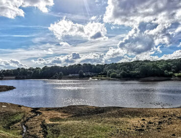
This reservoir and valley walk allows you to picturesque Jumble Country Park from Bromley Cross station.
Highlights include:
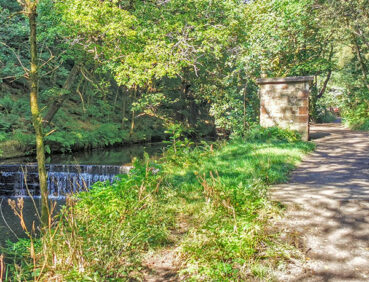
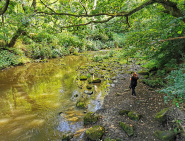
- The tree-lined Bradshaw Brook
- Views of the West Pennine Moors surrounding the reservoir
- Opportunities to enjoy a picnic from one of the tables overlooking the lake shore.
Note that parts of the trail may be damp, muddy and slippery after periods of wet weather. Please bear this in mind when planning your trip.
Be sure to keep your dog on its lead in sensitive areas, which include upland areas such as moorland, wetlands and mosslands, farmland, and parkland. Keeping dogs on leads helps protect both livestock and wildlife, especially ground-nesting birds.
This walk is available on the user-friendly Go Jauntly walking app. Here, photographs and written directions will enable you to follow the route on your phone. You can also download a printable PDF of the directions from the same link.
Alternatively, you can follow the route (without written directions) on the mobile-friendly Plotaroute site. To use Plotaroute on your phone’s browser, simply click the map. Then, when you’re ready to start walking, click the tracker icon (bottom right) to show your position as you follow the route.
We recommend carrying an additional power source and/or map when following online routes on your phone. For any challenging routes, we would recommend that you also have access to and know how to read an Ordnance Survey map.
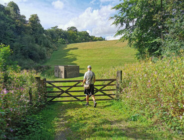
Shortly after the start of the walk, where the path leaves Grange Road, there is a fairly steep descent to Bradshaw Brook and a corresponding ascent afterwards. This section could be tricky to negotiate in icy weather. Apart from this, all of the paths are level.
The paths used are well-made and include the roadway of Grange Road (where you will need to watch out for vehicles) and tarmac and compacted gravel paths around the reservoir. Mud and puddles may be encountered on certain sections.
You will need to watch out for bikes on the eastern shore, as the path here is also a cycleway.
The paths and terrain encountered on this walk are shown and described on the Go Jauntly version of the walk, enabling you to make your own assessment of whether the route is accessible for you.
However, the varied terrain involved in this route means that the overall route is not suitable for wheelchairs, although those with pushchairs should be fine if they can manage the slopes described under ‘Terrain’ above. Wheelchair users could park at the Jumbles Country Park visitor centre (postcode BL2 4JS), and follow part of the onward route around the reservoir (though there may be some uneven sections). Please visit our Shorter walks page for a selection of other step-free walks on the GM Ringway trail.
Public toilets, including accessible facilities, can be found at the visitor centre car park, though in practice we have found that toilet availability cannot be guaranteed. In addition, the Railway pub is just next to Bromley Cross station at the start and end of the walk. For location details, see the Plotaroute map.
There are several benches and picnic tables along the way.
As the GM Ringway is designed around the tram, train and bus network, we recommend the use of public transport to access the start and end points. However, we also provide tips for drivers below.
Start and end points
There are two locations where you can start and end the walk: Smithy Bridge station for those arriving by train (and completing the longer walk) or Jumbles Country Park car park, which is more suitable for those with accessibility needs. To work out how to get to and from either location, simply click the link below to see the location in Google Maps. Then click ‘Directions’ and enter your starting location. For public transport options, click the train icon.
Start point 1: Bromley Cross station BL7 9LY
Start point 2: Jumbles Country Park visitor centre BL2 4JS
Alternatively, input the locations shown on this page into the TfGM journey planner.
Public transport
The walk starts and finishes at Bromley Cross station, served by trains 7 days a week from Manchester and Bolton. Buses to Bolton also run from stops nearby.
Train times can be checked by visiting the National Rail website, while details of bus and tram services can be found on the TfGM journey planner.
Recommended tickets
If you are travelling only by train, you can purchase a return ticket from your starting location to Bromley Cross. You can check the price of these on the National Rail website. Tickets can be purchased online or from the ticket office or machine at the station.
For those accessing the walk by bus, buses within Greater Manchester cost £2 for a single ticket and £5 for an AnyBus ticket, valid for multiple bus journeys all day and obtainable from the driver (prices correct as of March 2024).
If you are travelling by a mix of buses, trains or trams, then a combined day ticket might be cheaper. Check the TfGM Tickets and passes page to find the best option (selecting ‘1 day and return’ as your answer to ‘How often would you be travelling?’).
Parking
The best option for non-wheelchair users and for completing the full walk is to park at Bromley Cross Rail station Park and Ride (postcode BL7 9PZ), with parking for 71 vehicles but no disabled spaces. There is also parking at Jumbles Country Park visitor centre (postcode BL2 4JS), with a separate disabled parking area near the cafe.
We have no reports of any issues affecting this walk. Please let us know if you encounter any problems by completing this short form.