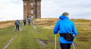
The GM Ringway – Greater Manchester’s walking trail – is a resource for all of the city-region’s residents and visitors. Here, we provide all the information you need to walk or wheel the trail. If you have any other questions, feel free to get in touch and we’ll do our best to help.
However, please note that while the GM Ringway Association (GMRA) strives to ensure that every stage of the GM Ringway trail is safe, it is not responsible for the condition of the trail on a day-to-day basis. The GM Ringway route can also be subject to diversions at short notice, and the weather can cause unexpected issues.
Further, the GMRA cannot be held responsible for the preparedness – or fitness levels – of anyone attempting to walk or run the trail. Anyone undertaking the GM Ringway therefore does so at their own risk, and we would ask that anyone planning to walk one or more sections of the trail use their own judgement before setting out.
For more on our terms and conditions, click here.
The 200-mile (322-km) route of the GM Ringway naturally falls into four broad sections, each made up of five one-day stages:
• The Southern Start-Up
• The Exhilarating East
• The Noble North
• The Western Wind-Down
Read more about the sections and stages on our route page.
Each of the four broad sections of the GM Ringway is made up of five ‘stages’. All 20 stages are designed to be walkable in one day, measuring between 7 miles and 13 miles in length.
What’s more, each stage starts and finishes at a public transport stop within Greater Manchester – in most cases a train station or tram stop – that has scheduled services seven days a week.
Most of the stages also have other public transport stops along the way, enabling you to walk just part of a stage if you prefer.
Visit the Route page to see a list of – and links to – all 20 stages for full details of what to expect on each route.
| Theoretically, you could start walking the GM Ringway from anywhere along its 200-mile (322-km) route. However, especially if you plan to walk the whole trail, we would recommend starting with Stage 1 in Manchester City Centre. This means you’ll start and finish at the official ‘trailhead’ in St Peter’s Square. You’ll also begin with the five shortest and easiest stages, enabling you to build up your fitness for the longer and hillier stages in the east and north. |
We think you’ll find it much easier to follow the GM Ringway in the anti-clockwise direction described. This is because:
• The route has been mapped and is being waymarked in this direction
• You get to start with the shorter and easier ‘Southern Start-Up’ stages before building up to the hills of the ‘Exhilarating East’ and ‘Noble North’
• Although the final five stages of the ‘Western Wind-Down’ are all fairly level, they are longer than the first five southern stages
• If you start with Stage 20 and work backwards, you’ll hit one of the biggest hills of the trail – Bolton’s of Winter Hill on Stage 14 – without any hill practice before then!
The GM Ringway has partnered with the Go Jauntly app to provide a free-of-charge and user-friendly walking app for all 20 stages of the trail, as well as ten shorter or step-free walks.
Simply download and sign up to the Go Jauntly app to track your position along the routes and enjoy photographs, written directions and a printable PDF for each stage.
All 20 stages on the Go Jauntly app can be found here.
For the ten shorter or step-free walks, see here.
For any support questions, please check out this page on the Go Jauntly website.
We recommend carrying an additional power source and/or map when following online routes on your phone. For any challenging routes, we would recommend that you also have access to and know how to read an Ordnance Survey map.
Remember that all walks are undertaken at your own risk, as stated in the GM Ringway terms and conditions.
Alternatively, you can follow the route (without written directions) on the mobile-friendly Plotaroute site. Each of the stage pages on our website also includes a link to the Plotaroute map for that stage. Similarly, our shorter and step-free walks all include a Plotaroute link.
We would recommend checking these maps even if you are using Go Jauntly or another app, as they include useful information such as any diversions you might need to follow and show public transport access points and other facilities along the route.
To use Plotaroute on your phone’s browser, simply click the map. Then, when you’re ready to start walking, click the tracker icon (bottom right) to show your position as you follow the route.
For further details of how to navigate using Plotaroute, visit this page on the Plotaroute website.
Remember that all walks are undertaken at your own risk, as stated in the GM Ringway terms and conditions.
By clicking the Go Jauntly link on each of the stage pages or shorter walk pages on this site, you can also download an up-to-date PDF version of that walk.
These PDF documents include basic maps and turn-by-turn directions to help you follow the walks.
However, some of the longer walks may run to several pages. You might also need to supplement the maps with an Ordnance Survey map or other resource when following a countryside route. We hope to be able to provide user-friendly printed leaflets in future, if funding allows.
Remember that all walks are undertaken at your own risk, as stated in the GM Ringway terms and conditions.
We are currently (in spring 2024) in the process of waymarking the whole of the 200-mile-long GM Ringway – a mammoth task being completed with the aid of our volunteers.
These waymarks are designed to aid walkers as they follow the trail and many of them also provide information by means of a QR code that directs you to the website.
Although we hope these are very useful, we strongly recommend that you also use other resources, such as our Plotaroute maps or the Go Jauntly app and, on challenging stages, an Ordnance Survey map.
Remember that all walks are undertaken at your own risk, as stated in the GM Ringway terms and conditions.
On many stages of the GM Ringway, we describe and show diversions and detours on each of the stage pages, on the Plotaroute maps and, where possible, on the Go Jauntly app.
These alternative routes involve:
- temporary diversions that may be in place due to a path blockage or closure, for example
- optional extensions that allow you to visit additional features of interest
- in some cases, shortcuts or other options for following an alternative route.
It is therefore well worth reading through the relevant stage information (on the site, app and Plotaroute map) when planning your trip to help you decide on the best and any detours.
If you’d like to record and celebrate your progress in walking or wheeling the GM Ringway, why not join one of our two ‘Challenges’ on the Go Jauntly app:
- The GM Ringway Challenge encourages you to complete all 20 stages of the trail as you walk a total distance of 200 miles (322 km)
- Those looking to walk or wheel on shorter or step-free sections of the trail can opt for the GM Ringway Explorer challenge; the aim here is to complete any five of the ten shorter walks we have mapped and described.
These challenges are especially useful if you want to walk the GM Ringway trail for charity. See our Get involved page for more details of fundraising using the GM Ringway.
For those who are new to walking or simply enjoy the social side of walking with a group, we arrange or support a number of guided walks and events over the year.
Some of these are organised by the GM Ringway team, while others are offered by partner organisations across Greater Manchester. The events involved include:
- themed walks, for example on mindfulness or nature,
- heritage walks,
- easy-access walks for all, and
- walks that form part of regular walking groups’ schedules.
Check out our News and events page for details of the latest activities on offer.
Please note that we are currently (as of summer 2025) unable to provide insurance to cover walks led by GM Ringway volunteers but hope to do so in the near future.
To ensure we can offer even more events and guided walks for the general public, we need walk leaders and other helpers such as ‘backmarkers’, who make sure people don’t get left behind.
If you have experience of leading or assisting with walks, please email us on info@gmringway.org. We’ll support you all the way.
Alternatively, if you want to organise a team-building event on the GM Ringway or a walk – or series of walks – for your community group, family or friends, you can:
- visit our Route and Shorter walks pages to select a route that best fits your needs
- use the Go Jauntly app to plan and follow the route
- contact us for support.
Please note that we are currently (as of summer 2025) unable to provide insurance to cover walks led by GM Ringway volunteers but hope to do so in the near future.
For those looking for a walk that samples part of the GM Ringway, our shorter walks are perfect. Covering all ten boroughs of Greater Manchester, each walk is accessible by public transport.
We have included five totally step-free GM Ringway walks within the shorter walks on our website and the Go Jauntly app. These are ideal for families with young children and people with mobility challenges.
While we believe that these routes are suitable for wheelchairs and pushchairs, we cannot guarantee this, so be prepared to retrace your steps if you encounter any problems.
In addition, many of the stage pages on our website give details of other step-free walks that are available along the way.
For other short walk options, you can always follow part of one of the 20 main stages of the GM Ringway. Simply visit our Route page and select one of the stages you’d like to sample. Then scroll down below the map and click ‘Getting there’. At the bottom of this section, ‘Cut-off points’ give details of locations where you can join or leave each stage by public transport.
Using this information, you can either:
- Divide many (but not all) of the stages into shorter sections and thereby complete a stage over more than one day, or
- Simply use part of a stage as an enjoyable short walk in its own right.
If you’d like to raise funds for a good cause while walking or wheeling on the GM Ringway, please take a look at the following:
- check out our News and events page to read about collaborations; in summer 2024, for example, there was a Summertime Trek, raising valuable funds for Forever Manchester, Greater Manchester’s Community Foundation
- organise your own charity walk on the GM Ringway; using resources such as the Go Jauntly app and our guide Tips and advice for charity fundraising using the GM Ringway trail
- by contacting us for advice and / or support on publicising your walk.
Don’t forget to share your experiences of any charity walks with us, by tagging #GMRingway on your Facebook, and Instagram posts.
As the GM Ringway is designed around Greater Manchester’s tram, train and bus network, we recommend the use of public transport to access the start and end points. However, we realise that many people may find the process of planning public transport tricky, especially for the trail stages, which are all linear (A-to-B) walks.
For these reasons, for all of our routes (both trail stages and shorter walks):
- We show public transport access points (tram stops, train stations or bus stops) on the web page, Go Jauntly app, and Plotaroute map
- On all walk pages (under ‘Getting there’), we give specific details of the best public transport and ticketing options for the trail stage or shorter walk concerned.
We would advise you to read the ‘Getting there’ section on each walk page when planning your GM Ringway walk – and, of course, to check public transport timetables online to be aware of any delays or cancellations. Train times can be checked by visiting the National Rail website, while details of bus and tram services can be found on the TfGM journey planner.
We realise there will always be some trail users who want to use their car to access walks for a variety of reasons. For this reason, all of our routes (both trail stages and shorter walks) include tips for drivers.
To find these, visit the relevant walk page using the links above and scroll down to ‘Getting there’. In this section, under ‘Parking’, we recommend the most convenient places to park so that you can get to and from the walk by car. For the trail stages, this will involve parking your car in one location and using public transport to get to or from the walk start or end point.
Part of the pleasure of a good walk is to stop at a local café or pub along the way. We therefore show places where you can take a break for refreshments:
- On our ‘Places to visit’ page, where you’ll see an overview map of the whole GM Ringway trail, with icons indicating cafes, pubs and restaurants along the way
- On each of our trail stage pages, where a more detailed map shows facilities on each walk.
You can filter the places to visit shown on those maps by categories such as ‘Eat & drink’.
In addition, on each walk page you can scroll down to ‘Accessibility and facilities’. Here we describe refreshment options (and toilets) along the way, some of which might not yet be shown as places to visit on the map – though we are adding more locations all the time.
When you’re out walking or wheeling on the GM Ringway, it’s important to keep up your energy and hydration levels. You should therefore always carry sufficient water with you, a snack or two and – on longer walks – a packed lunch. Especially on the longer trail stages, there can be gaps of several miles where no facilities are available.
Because the GM Ringway is built around the local public transport network, Greater Manchester residents can generally access the trail as a series of day trips from their home base.
However, as the trail passes through lovely countryside and takes in some fascinating heritage attractions, both residents or visitors might want to book a hotel or B&B along the route. We are therefore gradually adding a selection of ‘Places to stay’ to the maps shown on our ‘Places to visit’ and trail stage pages.
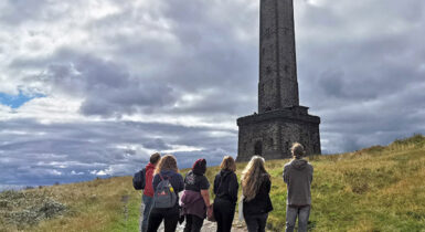
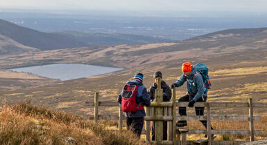
One of the best things about the GM Ringway is the access it provides to a range of museums, historical sites and designated nature protection sites. The maps shown on our ‘Places to visit’ and trail stage pages therefore include icons for ‘Heritage attractions’ and ‘Nature & parks’ that lie on or near the trail. In addition, the ‘Overview’ on each walk page details some of the historical, geological and natural highlights that you’ll pass along the way.
Completing all of the 200-mile (322-km) GM Ringway is quite a challenge even for seasoned hikers. However, we’ve made things as easy as possible for new or returning walkers by:
- Designing the trail route to start with five shorter and more level stages, so that you gradually build up your fitness for the hillier and longer stages in the east and north
- Describing each stage in detail on both the website and the Go Jauntly app so that you can decide whether it matches your fitness level
- Providing a series of shorter and in some cases step-free GM Ringway walks so that everyone can walk or wheel parts of the trail.
Although the GM Ringway was devised as a walking trail we have found that the trail is increasingly popular with runners. One brave soul has even run the entire 200-mile (322-km) route in one go as an ‘ultra challenge’in May 2024!
To use the trail on popular running apps, such as Strava, you can download GPX files for the individual stages from the Plotaroute collection of maps, which we update regularly. We would also advise you to check the various stage pages on the website to read about transport options, facilities and any diversions in place.
The GM Ringway is made up of a variety of existing paths that are almost all available to walkers with dogs. The only exception is Stage 15, where a short reservoir section is closed to dogs for environmental reasons. Here, we detail a straightforward diversion for those with dogs.
However, some of the trail stages include stiles that may be difficult to cross for those with larger dogs. We are gradually updating each walk page on the website – see the ‘Terrain’ section – to include details of stiles. In the meantime, check the Go Jauntly versions of each walk to see if there are stiles along the way.
Be sure to keep your dog on its lead in sensitive areas, which include upland areas such as moorland, wetlands and mosslands, farmland, and parkland, such as National Trust estates. Keeping dogs on leads helps protect both livestock and wildlife, especially ground-nesting birds.
Because of the nature of the GM Ringway – which explores a variety of landscapes using existing paths across varied terrain – wheelchair-users will unfortunately be unable to tackle the entire route.
However, to ensure everyone can benefit from the trail, we have described a set of step-free GM Ringway walks that are suitable for a wide variety of users. We hope to identify and add further step-free walks in future, if funding allows.
With our partners, we also organise regular step-free ‘walks for all’, which are listed on our News and events page.
In addition, many of the stages of the trail visit locations with good wheelchair- and pushchair friendly paths. These are described in the ‘Accessibility and facilities’ section on each of the trail stage and shorter walk pages.
The GM Ringway is very much a resource for families. Indeed, one of our project aims is to get people of every age walking and exploring the local area.
The best way to decide whether a particular route is suitable for your children and family members is to visit the trail stage and shorter walk pages. There, we give details of the walk length, the ascent involved, the terrain encountered, and the facilities along the way. The Go Jauntly app and PDF descriptions also show and describe sections, such as canal towpaths, and exposed hillside paths, where you may need to keep a close eye on children.
Those with babies or toddlers in pushchairs are advised to read our tips for wheelchair-users above.
Unlike an active travel scheme that often involves the creation of new multi-user paths, the GM Ringway is made up of existing public footpaths, bridleways and other paths covering all kinds of terrain. Many of these paths are not suitable for bikes and are not open to cyclists by law.
Each trail stage also connects different public transport lines, including bus and tram routes on which bicycles cannot be carried.
For these reasons, the GM Ringway is specifically designed as a walking trail, complementing the cycle routes that already exist or are being developed. To view a wide range of routes around Greater Manchester recommended for cyclists, please visit the Sustrans website.
As outlined under the information for cyclists above, the GM Ringway is made up of existing public footpaths, bridleways and other paths covering all kinds of terrain. Many of these paths are not suitable for horses and are not open to equestrians by law.
However, parts of the GM Ringway intersect with trails that are designed for both walkers and equestrians. Visit the Trans Pennine Trail, Pennine Bridleway and Middlewood Way websites for details.
One of the key aims of the GM Ringway project is to extend the benefits of outdoor activity, nature-connectedness and heritage to all of Greater Manchester’s residents and visitors. That being said, as a walking trail built around existing paths over a wide variety of terrain, the GM Ringway in its entirety will not, by its nature, be accessible to every individual.
We therefore aim to fulfil our ambition of a ‘trail for everyone’ by:
- Providing accessibility information on each of our so that users can decide whether that specific walk is accessible for them
- Identifying and describing routes along the trail that are step-free and therefore accessible to a wider range of users
- Ensuring that our digital resources – both our website and the Go Jauntly app on which our walks are hosted – fulfil the accessibility standards required for Heritage Fund-supported projects.
If you have any suggestions about how we could make our project even more accessible and inclusive, please email us on info@gmringway.org.
For detailed information on the accessibility of each of our walking routes, visit our trail route and shorter walk pages. Scroll down to two sections that provide relevant information on accessibility:
- Firstly, the ‘Terrain’ section describes the gradients encountered, the types and quality of path used, any sections especially prone to mud or puddles, and any hazards such as paths shared with bikes.
- Secondly, under ‘Accessibility and facilities’ you can find out whether or not the route or parts of it are suitable for wheelchair or pushchair users. Information is also given on toilet availability along the route (including accessible toilets, where known) and other facilities such as pubs and cafes.
In addition, the paths and terrain encountered on each walk are shown in photo form and described on the Go Jauntly version of the route, enabling you to make your own assessment of whether the route is accessible for you.
Our set of shorter walks includes five totally step-free GM Ringway walks, which are also described and illustrated in photographic form on the Go Jauntly app. These are ideal for families with young children and people with mobility challenges.
While we believe that these routes are suitable for wheelchairs and pushchairs, we cannot guarantee this, so be prepared to retrace your steps if you encounter any problems.
We hope to identify and add further step-free walks in future, if funding allows.
As you will see on our trail stage and shorter walk pages, we provide information for route-finding in the form of maps on the mobile-friendly Plotaroute site, and directions, photographs and maps on the Go Jauntly app and PDF files.
Even so, these maps and directions are provided for guidance only and we cannot guarantee their accuracy. We accept no responsibility for any errors or omissions or for any injuries or accidents that occur while following our walks.
We recommend carrying an additional power source and/or map when following online routes on your phone. For any challenging routes, we would recommend that you also have access to and know how to read an Ordnance Survey map.
It is important to ensure that you are fit enough to complete the particular GM Ringway walk you have selected. Our trail stage and shorter walk pages provide information on the distance, estimated time, grade and ascent involved in each walk.
If you are unsure about your fitness to complete a walk independently, we would recommend joining a guided walk on the trail. Many of these are listed on our News & Events page. For details of local group walks around Greater Manchester, many of which feature parts of the GM Ringway, visit the Greater Manchester & High Peak Ramblers website.
To walk the GM Ringway trail and some of our shorter walks, we would recommend:
- Walking boots (for any challenging routes) or sturdy and waterproof trainers or walking shoes; note that parts of the GM Ringway can be muddy, damp or slippery at any time of the year and especially after extended periods of wet weather; ordinary trainers or sandals may be suitable for some of our shorter walks
- Clothing that you can ‘layer’, i.e. wear or take off depending on the conditions, including a waterproof jacket or anorak and a fleece, gloves and hat in colder conditions
- In sunny weather, sun protection gear, such as a sunhat, suncream and sun cream
- A rucksack so that you can store snacks and drinks and any additional clothing or maps while keeping your hands free
- Adequate food and drink, including plenty of water, snacks, and for longer walks a packed lunch.
Walking poles can also be useful to cope with mud, puddles and steep ascents and descents, as can a first aid kit, compass, whistle and torch for any challenging routes. For further tips on what to wear when walking, visit the Ramblers website.
Before completing any walk, and especially any of our routes with a ‘Challenging’ grade, you should check the weather and conditions online. Simply type in the town or postcode close to your walk for a local forecast on either the BBC Weather or Met Office websites.
Note, however, that the temperature can often be several degrees cooler – and conditions windier and more exposed – at the higher altitudes reached on the eastern and northern sections of the GM Ringway.
Once out on a walk, keep an eye on the weather, as conditions can change, and prepared to turn back or use one of the recommended ‘cut-off points’ if conditions turn against you.
The Ramblers website includes a very useful set of articles about walking safely. This includes tips on hillwalking in winter, summer walking, and even staying safe when walking near cattle and other animals.
We also recommend reading the ‘Stay safe’ guide provided by Mountain Rescue England and Wales.
Finally, remember that all walks are undertaken at your own risk, in accordance with our terms and conditions.
The Countryside Code is your guide to enjoying parks and waterways, coast and countryside across the UK. It states that visitors to the countryside should:
Respect everyone
- be considerate to those living in, working in and enjoying the countryside
- leave gates and property as you find them
- do not block access to gateways or driveways when parking
- be nice, say hello, share the space
- follow local signs and keep to marked paths unless wider access is available
Protect the environment
- take your litter home – leave no trace of your visit
- do not light fires and only have BBQs where signs say you can
- always keep dogs under control and in sight
- dog poo – bag it and bin it in any public waste bin or take it home
- care for nature – do not cause damage or disturbance
Enjoy the outdoors
- check your route and local conditions
- plan your adventure – know what to expect and what you can do
- enjoy your visit, have fun, make a memory
The Towpath Code, published by the Canal & River Trust, encourage everyone to be more aware when using towpaths, many of which feature on the GM Ringway route. On towpaths, the following rules apply:
- Pedestrians have priority
- Cyclists must slow down for others
- Take extra care when passing people, pets and wildlife
- Respect people using the waterway for activities like angling, boating or paddle sports
- Wheelchairs, mobility aids, cycles and legal e-bikes are allowed
- E-scooters, motorbikes, modified e-bikes and other unauthorised vehicles are not allowed
- Keep dogs under close control and clean up after them
- Take litter home
Every year fire destroys thousands of acres of countryside and wildlife habitats – including the fires that devastated moorland in Greater Manchester and surrounding areas during summer 2018. Some fires are started deliberately, but many are due to carelessness.
For this reason, we recommend reading the Greater Manchester Fire and Rescue Service guidelines on avoiding and reporting moorland fires before tackling any GM Ringway routes that explore moorland areas (mainly on the eastern and northern sections of the trail).
In addition, a ‘Public Spaces Protection Order’ (PSPO) has now been introduced and is in force in the Winter Hill and neighbouring areas visited on Stage 14 of the GM Ringway. The protection order effectively bans all of the following from public moorland in the area for the next three years:
- Campfires
- Barbecues
- Camping stoves
- Chinese lanterns
- Fireworks
- Any other activity that could cause a fire.
The GM Ringway terms and conditions are detailed on the CPRE website. A key point to note is that all walks are undertaken at your own risk.
We are working closely with Peak & Northern Footpaths Society (PNFS) and The Ramblers to help respond to problems that you may encounter with the trail condition, including reporting issues to the relevant local authority.
PNFS is a charity committed to protecting your right to access the outdoors. They do this by monitoring, protecting and improving public rights of way such as footpaths and bridleways.
The easiest way to report any problems you find on the trail is by using the PNFS app called Path Checker, available to download free for IOS and Android smart phones.
Hence for issues relating to the trail condition, we would recommend you contact PNFS directly either by using the Path Checker app or via the PNFS website: Peak & Northern Footpaths Society – Report a problem (or Lost Way) (peakandnorthern.org.uk)
It is worth noting that maintenance on most of the trail is the responsibility of the relevant local authority, and you may also wish to contact them directly.
For anything else, please contact us on info@gmringway.org.
Walk the trails
The route
See all 20 stages of the varied and beautiful 200-mile (322-km) route. Accessible by public transport at the beginning and end of each stage and covering all ten boroughs.
Shorter walks
For those looking for a walk that samples part of the GM Ringway, our ten shorter walks are perfect. Accessible by public transport with five step-free routes.