The final stage of the GM Ringway connects Stretford with Manchester city centre via a series of largely traffic-free waterside paths. The route includes some little-known green spaces and an astonishing series of museums and heritage sites from every age, making it a worthwhile full-day outing.
Highlights include:
- The striking structure of Imperial War Museum North, designed by US architect Daniel Libeskind
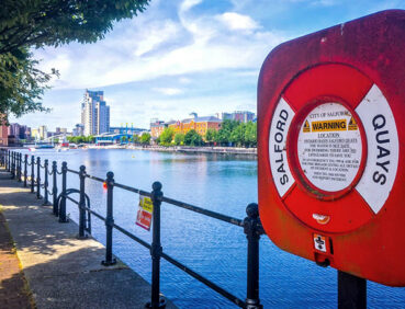
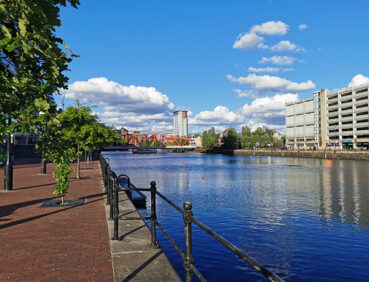
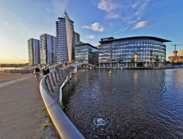
- The vibrant waterside attractions of Salford Quays
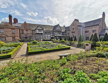
- The Grade I-listed Ordsall Hall, a 15th-century manor house surrounded by Elizabethan gardens
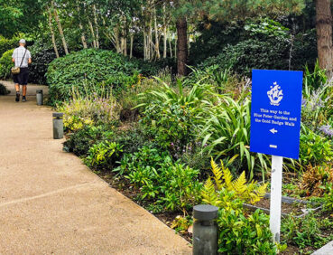
- Riverside paths along the Manchester Ship Canal and River Irwell, the surprisingly peaceful waterways separating the cities of Manchester and Salford
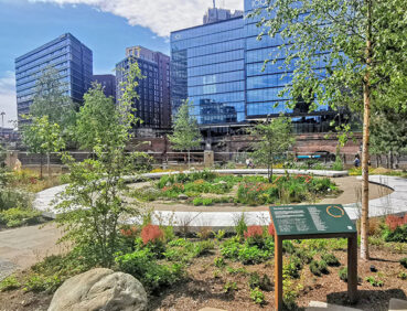
- A wander between green and traffic-free spaces of the city centre, including optional short loops to explore Castlefield’s Roman gardens and fort and the Medieval Quarter.
Note that parts of the trail may be damp and slippery at any time of year and especially after periods of wet weather. Please bear this in mind when planning your trip.
Be sure to keep your dog on its lead in sensitive areas, which include upland areas such as moorland, wetlands and mosslands, farmland, and parkland. Keeping dogs on leads helps protect both livestock and wildlife, especially ground-nesting birds.
This walk is available on the user-friendly Go Jauntly walking app. Here, photographs and written directions will enable you to follow the route on your phone. You can also download a printable PDF of the directions from the same link.
Alternatively, you can follow the route (without written directions) on the mobile-friendly Plotaroute site. To use Plotaroute on your phone’s browser, simply click the map. Then, when you’re ready to start walking, click the tracker icon (bottom right) to show your position as you follow the route.
We recommend carrying an additional power source and/or map when following online routes on your phone. For any challenging routes, we would recommend that you also have access to and know how to read an Ordnance Survey map.
This route is almost entirely level. Furthermore, virtually all of the paths used are hard-surfaced, though there are some cobbled and uneven sections where you should pay attention to your footing. There are very few stepped sections apart from a set of low steps onto and down from the canal bridge just after the 1-mile/1.60-km point, and a flight of steps where you leave the canal just before the 2.5-mile/4-km point.
You will need to watch out for bikes on the Bridgewater Canal sections in particular.
The paths and terrain encountered on this walk are shown and described on the Go Jauntly version of the walk, enabling you to make your own assessment of whether the route is accessible for you.
However, the few stepped and cobbled sections involved in this route means that the overall route is not suitable for wheelchairs or pushchairs. Please visit our Shorter walks page for a selection of step-free walks on the GM Ringway trail. These include a step-free walk around Salford Quays, featured on this stage. Much of the Bridgewater Canal towpath, and the paths at MediaCity and along the Salford and Trafford waterfronts are also step-free and suitable for all users.
Payable public toilets (including accessible facilities) can be found in Stretford Mall (near the start of the route) during opening hours. Along the way, toilets open to the public can also be found between the 3-mile/5-km and 4-mile/6.5-km points in the Imperial War Museum North, the Lowry arts centre and the Lowry Shopping Mall. At the end of the walk, free-of-charge public toilets (including accessible facilities) are passed in the Town Hall Extension in Mount Street.
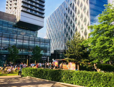
There are countless refreshment opportunities on this stage of trail, first of all at Hotel Football (at the 3.5-mile/5-km point) and 1 mile/1.6 km later in and around MediaCity. There is a café at Ordsall Hall when the museum is open. Once the trail reaches crosses the Irwell, at the 6-mile/9.6-km point near Aviva Studios, you will pass a massive number of bars, cafes and restaurants in the city centre.
For location details, see the Plotaroute map.
As the GM Ringway is designed around the tram, train and bus network, we recommend the use of public transport to access the start and end points. However, we also provide tips for drivers below.
Start and end points
To work out how to get to and from the walk start end points, simply click the links below to see the location in Google Maps. Then click ‘Directions’ and enter your starting location. For public transport options, click the train icon.
Start point: Stretford tram stop M32 8HN
End point: St Peter’s Square tram stop M2 5PD
Alternatively, input the locations shown on this page into the TfGM journey planner.
Public transport
This trail stage connects served by Metrolink trams from Altrincham and Manchester, and with several bus services nearby, with St Peter’s Square, served by trams from across the network (and close to city centre bus and train terminals). Details of bus and tram services can be found on the TfGM journey planner while train times can be checked by visiting the National Rail website.
Recommended tickets
If you are travelling only by tram, you will need a Metrolink ticket to cover the zones you travel through. You can check the price of these on the Bee Network website and then purchase your ticket from the machine at the stop or tap in and out with your bank card.
If you are travelling by a mix of buses, trains or trams, then a combined day ticket might be cheaper. Check the TfGM Tickets and passes page to find the best option (selecting ‘1 day and return’ as your answer to ‘How often would you be travelling?’).
Parking
Drivers are advised to park at Stretford Metrolink Park & Ride (postcode M32 8HW), where there is parking for 35 vehicles (and 2 disabled spaces). After the walk, you can then return to your car by tram from St Peter’s Square. However, this car park may fill up quickly on days when Manchester United is playing or at other busy times.
Other park and ride facilities with greater capacity are available elsewhere on the Metrolink tram network. Probably the most convenient one is at Brooklands Metrolink Park & Ride (postcode M33 3SS), also on the Altrincham-Stretford-Manchester line, with parking for 84 vehicles (but no disabled spaces). From there, you can take a direct tram to Stretford to start the walk and, later, one back from St Peter’s Square at the end of the walk.
Cut-off points
If, for example, you only want to walk a section of the stage, you can most easily leave or access the route at one of the several Metrolink tram stops that are on or close to the route. These include Wharfside, Imperial War Museum, and MediaCityUK. For location details, see the Plotaroute map.
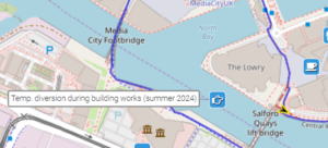
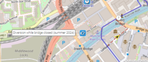
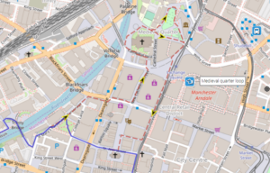
Four alternative routes are shown on the Plotaroute map.
The first, at Salford Quays, is due to building works in summer 2024 and involves walking onto the lift bridge and then turning left down steps:
The second, in the city centre, is an optional and worthwhile extension around Castlefield’s Roman Gardens, where you can view the reconstructed Roman Fort:

Thirdly, further on in the city centre, a route is shown avoiding the footbridge from Spinningfields to Salford. This is closed due to building works and damage to the bridge (as of summer 2024):
Finally, an optional extension is shown around Manchester’s ‘Medieval Quarter’. This worthwhile route can be busy especially on weekends and holidays:
To give any feedback or notify us of any issues with this route, please complete this form.