This stage connects Wigan and Leigh via England’s newest National Nature Reserve: the ‘Flashes of Wigan and Leigh’. The reserve was formally designated in October 2022 in recognition of the area’s natural beauty and immense ecological importance.
Highlights include:
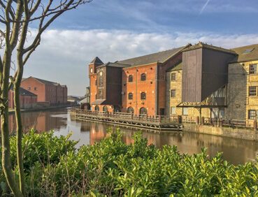
- Wigan’s historic industrial sites including the site of Wigan Pier, made famous by George Orwell
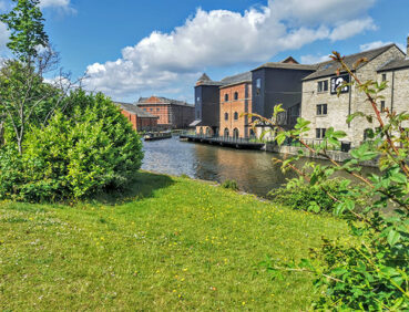
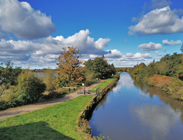
- The Leigh Branch of the Leeds & Liverpool Canal, including a delightful section running between two of the largest flashes (lakes formed as a result of mining subsidence)
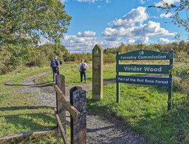
- Some lesser-known countryside, including the fringes of Three Sisters country park and the mixed woodland of Viridor Wood
- Lightshaw Meadows, an area of grassland that has been designated as an SSSI (Site of Special Scientific Interest) thanks to its rich variety of flora and fauna
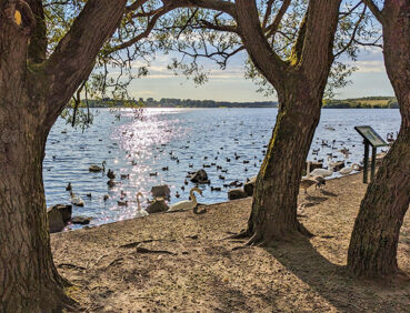
- Pennington Flash, nationally renowned for its birdlife and the second-largest body of water in Greater Manchester.
Note that parts of the trail may be damp, muddy and slippery at any time of year and especially after periods of wet weather. Please bear this in mind when planning your trip.
Be sure to keep your dog on its lead in sensitive areas, which include upland areas such as moorland, wetlands and mosslands, farmland, and parkland. Keeping dogs on leads helps protect both livestock and wildlife, especially ground-nesting birds.
This walk is available on the user-friendly Go Jauntly walking app. Here, photographs and written directions will enable you to follow the route on your phone. You can also download a printable PDF of the directions from the same link.
Alternatively, you can follow the route (without written directions) on the mobile-friendly Plotaroute site. To use Plotaroute on your phone’s browser, simply click the map. Then, when you’re ready to start walking, click the tracker icon (bottom right) to show your position as you follow the route.
We recommend carrying an additional power source and/or map when following online routes on your phone. For any challenging routes, we would recommend that you also have access to and know how to read an Ordnance Survey map.
The great majority of this route is level, with one brief, fairly steep ascent at the 7.5-mile/12-km point north of Pennington Flash.
Most of the paths are well-made. Even so, mud and puddles are likely on certain sections, especially after the 5-mile/8-km point where you pass under the railway and then cross an area of wetlands. A detour is described here under ‘Diversions and trail updates’ below that should be used in flood conditions. Some of the paths north of Pennington Flash can also be muddy and slippery. You will also need to watch out for bikes on the canal towpath.
The paths and terrain encountered on this walk are shown and described on the Go Jauntly version of the walk, enabling you to make your own assessment of whether the route is accessible for you.
However, the varied terrain involved in this route means that the overall route is not suitable for wheelchairs or pushchairs. Please visit our Shorter walks page for a selection of step-free walks on the GM Ringway trail. Many of the paths on the eastern edge of Pennington Flash are also step-free and well-surfaced.
There are ample facilities, including cafes, pubs, shops and toilets, at the start of the walk in Wigan town centre. As well as the public toilets in the Grand Arcade shopping centre, those in Wigan North Western station can be accessed even by those without rail tickets.
After this point, there very few refreshment or toilet opportunities for a good 7 miles/11.5 km or so. The only exception is the Bryn Hall pub in Bamfurlong (just north of the 4.5-mile/7.3-km point), used mainly by locals, which generally opens at lunchtime.
At the 7.4-mile/11.9-km point, you can turn left along Plank Lane to reach the signposted Nevison Country Inn, which serves food. Alternatively, 1 mile / 1.6 km further on, you will reach the car park and visitor centre for Pennington Flash, where there is a café, toilets (including accessible facilities) and a large play park for children.
Finally, you will pass pubs on the approach to Leigh town centre, where a wide range of amenities are available including payable public toilets at the bus station, and pubs and cafes with toilets nearby.
Locations are shown on the Plotaroute map.
As the GM Ringway is designed around the tram, train and bus network, we recommend the use of public transport to access the start and end points. However, we also provide tips for drivers below.
Start and end points
To work out how to get to and from the walk start end points, simply click the links below to see the location in Google Maps. Then click ‘Directions’ and enter your starting location. For public transport options, click the train icon.
Start point: Wigan Wallgate station WN1 1BB
End point: Leigh bus station WN7 4LP
Alternatively, input the locations shown on this page into the TfGM journey planner.
Public transport
This trail stage connects Wigan (with its two train stations) with Leigh bus station. In Wigan, the two stations – Wigan Wallgate and Wigan North Western – are only 100 m apart and are served by direct trains from Manchester, Bolton and other locations. Buses also run to nearby Wigan bus station from multiple locations. Leigh bus station served by express buses to Manchester and Salford and by other buses to Wigan, Bolton and elsewhere.
Train times can be checked by visiting the National Rail website, while details of bus and tram services can be found on the TfGM journey planner.
Recommended tickets
If you are travelling to Wigan by train, you can purchase a single ticket from your local station. Note that tickets to or from Wigan are generally valid for either station there (Wigan Wallgate or Wigan North Western). You can check the price of these on the National Rail website. Tickets can be purchased online or from the ticket office or machine at the station.
To return from Leigh, buses within Greater Manchester cost £2 for a single ticket and £5 for an AnyBus ticket, valid for multiple bus journeys all day and obtainable from the driver (prices correct as of March 2024).
However, as you will be travelling on a mix of trains and buses (and possibly trams), then a combined day ticket might be cheaper. Check the TfGM Tickets and passes page to find the best option (selecting ‘1 day and return’ as your answer to ‘How often would you be travelling?’).
Parking
Depending on their home location, drivers may find it easiest to travel by train or bus to Wigan and by bus from Leigh. See ‘Public transport’ above.
Otherwise, the best option for an early start is to park at the walk start in Wigan. The most convenient location is the car park at Wigan Wallgate station (postcode WN1 1BB), where there is parking for 113 vehicles. Check the car park website for details and to pre-book a space. At the end of the walk, you can return by one of the regular buses from Leigh bus station to Wigan (journey time 35-55 minutes).
Cut-off points
If, for example, you only want to walk a section of the stage, there are several locations where public transport can be used to leave or to access the route. At the 4.5-mile/7-km and 5.5-mile/9-km points, you cross main roads from where buses run to and from Wigan. At the 7.5-mile/12-km point on Slag Lane, buses run to and from Leigh bus station. For location details, see the Plotaroute map.
Two alternative routes are shown on the Plotaroute map.
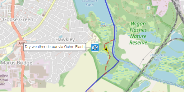
The first, just after the 2-mile/3.2-km point, shows an optional detour (suitable for dry conditions only) passing picnic tables and the viewing point for the pretty Ochre Flash:
The second, just after the 5-mile/8-km point, shows a diversion to avoid a waterlogged area (at times when flooding is likely). This entails following the path alongside the railway line (after the tunnel) and then using the road to access the canal. This adds 1 mile/1.6 km to the overall distance covered:

To give any feedback or notify us of any issues with this route, please complete this form.